
Listed Buildings of Lynsted, Kingsdown and Greenstreet
Drawing on Kent Historic Environment Record. This index includes listed buildings on the north side of Greenstreet (London Road) that falls inside Teynham Parish when "Greenstreet" was a identified as a distinct and important commercial centre. It was only after the First World War that Greenstreet's separate identity was brought into question by Faversham Post Office administration.
You can find more details of each Listing at:
- Kent Historic Environment Record (formerly Sites and Monuments Record); or
- Visit the Heritage Gateway as a portal to wider property or site records.
HER Number |
ADDRESS (and estimated date) | GRADE | Ministry Ref | |
| TQ 86 SW 132 | Watling Street Roman Road | |||
| 176246 | TQ 96 SW 1169 | Bumpit (Edward Hasted describes), Bogle Road (formerly Bumpit Farm Cottage) - c.1587 Once the work-house of the Parish. | II* | 2-36 |
| TQ 96 SW 281 | Oasthouse North West of Bumpit [prob. Late 18th Century] | |||
| MKE85575 | Loyerton Farm, Oast (altered) | |||
| MKE85576 | Outfarm to south west of Loyerton Farm | |||
| 176247 | TQ 96 SE 1088 and MKE88669 |
Tenacre Farmhouse, Bogle Road - 16th Century (and loose courtyard much changed) | II | 3/37 |
| 176248 | TQ 96 SE 1155 and MKE85569 |
Cambridge, Cambridge Road (formerly listed as Cambridge Farmhouse) -16th C. (and farmstead courtyard remains) | II | 3/38 |
| 176249 | TQ 96 SE 1080 | Tudor Cottage, Cellar Hill (formerly 2 cottages, 27.8.52 occupiers Hanford/Streatfield) - 16th C. | II | 3/39 L2-2-34 L2-2-982 |
| 176250 | TQ 96 SE 1156 | Cellar Hill Cottage, Cellar Hill (formerly No.25 The Old Cottage) - 16th C. | II | 3/40 L2-2-982 |
| 176251 | TQ 96 SE 1082 and MKE85566 |
Cellar Hill Farm, Cellar Hill (Waylands) - early-middle 18th C. [and Waylands farmstead L-plan largely unaltered] | II | 3/41 |
| 176252 | TQ 96 SE 1120 | The Old Thatched Cottage, Cellar Hill - 16th C. | II | 3/42 |
| 176253 | TQ 96 SE 1071 | Cherry Gardens, Cellar Hill - 16th C. | II | 3/43 |
| TQ 96 SE 43 | Medieval pottery scatter in grubbed and ploughed apple orchard near Cellar Hill. No structures | |||
| 176254 | TQ 95 NW 56 and MKE85475 |
Dadmans (Edward Hasted mentions this house), Christopher Row - 17th C., early 18c [and loose farm courtyard] | II | 4/44 |
| TQ 96 SW 247 | Lime kiln (site) at Dadmans Shaw | |||
| MKE85476 | Outfarm east of Dadmans [survives but completely altered] | |||
| MKE85471 | Lyndale. Farmstead much altered | |||
| 176255 | TQ 95 NW 51 | Yew Tree Cottage, Christopher Row - 15th C. | II | 4/45 |
| MKE85479 and MKE85478, MKE85477 |
Outfarm north of St Christophers Farm [behind Sunny Bank] - completely demolished. [and dispersed Farmstead - altered] | |||
| 176256 | TQ 95 NW 58 and MKE85480 |
Colyers Cottage (Colliers), Christopher Row - 17th C. | II | 4/45 |
| TQ 96 SW 233 | Hearth/Fire-pit of undetermined date, found at Claxfield Farm | |||
| TQ 96 SW 300 | Medieval ditches, Claxfield Farm | |||
| TQ 96 SW 301 | Late Bronze Age/Early Iron Age pottery, Claxfield Farm | |||
| 176257 | TQ 96 SW 1217 and MKE85531 |
Claxfield Farmhouse, Claxfield Road - 16th C. (and old courtyard) | II* | 2/47 |
| TQ 96 SW 189 | Union Mill (Corn Mill), near Claxfield Farm, Lynsted [Site only] | |||
| LB/LYN/0013 | TQ 96 SW 1095 | Jefferies, Claxfield Road - 16th C. | II | 2/48 |
| LB/LYN/0014 | TQ 96 SW 1216 and MKE85465 |
1 & 2 Sunderland Farmhouse (formerly Sundries), Claxfield Road - 16th C. | II* | 2/49 |
| LB/LYN/0015 | TQ 96 SW 1094 | The Batteries, Claxfield Road - 17th C., 19th C. | II | 2/50 |
| MKE85467 | Batteries (Butteries) Farmstead - Oast | |||
| LB/LYN/0016 | TQ 96 SW 1215 | Oasthouse and Oasts 30 yd SW of Batteries, Claxfield Road - early 19th C. | II | 2/51 |
| TQ 96 SW 1093 | 2/52 Barn 20 yards east of 5.1.77 Batteries | GV II | ||
| TQ 96 SW 1171 | Aymers (including Stables) | II | 2/10001 | |
| TQ 96 SW 184 | Icehouse, Aymers [demolished in 1925] | |||
| TQ 96 SE 201 | Milestone on the London Road (A2) at Teynham opposite Cellar Hill | |||
| LB/LYN/0018 | TQ 96 SE 1121 | 2 The Walnuts, London Road - 1825 | II | 3/53 |
| LB/LYN/0019 | TQ 96 SE 1065 | No.4 & Old Forge Building adjoining, London Road - late 17th C. | II | 3/54 |
| LB/LYN/0020 | TQ SE SE 1157 | 18 The Grange, London Road - 18th C. | II | 3/55 |
| LB/LYN/0021 | TQ 96 SE 1154 | 20 The Dover Castle PH, London Road - early 18th C. | II | 3/56 |
| LB/LYN/0022 | TQ 96 SE 1086 | 42 London Road - 16th C. | II | 3/57 |
| LB/LYN/0023 | TQ 96 SE 1124 | 52 London Road - 16th C. | II | 3/58 |
| LB/LYN/0024 | TQ 96 SE 1115 | 54-56 London Road - 17th C. | II | 3/59 |
| LB/LYN/0025 | TQ 96 SE 1117 | 70 London Road (formerly listed as 68 & 70) - c.1700 | II | 3/60 L2-2-155 |
| LB/LYN/0026 | TQ 96 SE 1097 | 72 London Road - 18th C. | II | 3/61 |
| LB/LYN/0027 | TQ 96 SE 1119 | 74 London Road - 1775 | II | 3/62 |
| LB/LYN/0028 | TQ 96 SE 1101 | The George Inn, London Road - 17th C. | II | 3/63 |
| LB/LYN/0029 | TQ 96 SW 1202 | 118 London Road - 18th C. | II | 2/64 |
| 122 The Hollies, London Road - early 19th C | Local List | - | ||
| LB/LYN/0030 | TQ 96 SW 1235 | Claxfield House, London Road (south side) - 17th C. (now offices) | II | 2/65 L2-2-251 |
| LB/LYN/0031 | TQ 96 SW 1226 | Anchor House, Ludgate Lane - 16th C., 20th C. | II | 2/66 |
| TQ 96 NW 12 | Chapel Cottage, Kingsdown Road (possible Toll House) | II | 1393121 | |
| LB/LYN/0032 | TQ 96 SW 1092 | Lynsted Court Cottage, Ludgate Lane (formerly listed House/Occupier - A G Phipps) - 16th C. | II | 2/67 L2-2-460 |
| LB/LYN/0033 | TQ 96 SW 1214 | 1 & 2 Oak Cottages, Ludgate House (formerly Oak House and Old Oak House) - 16th C. | II | 2/68 L2-2-460 L2-2-1050 |
| LB/LYN/0034 | TQ 96 SW 1225 | Lyndale, Ludgate Lane - 18th C. | II | 2/69 |
| LB/LYN/0035 | TQ 96 SW 1097 | Heathfield, Ludgate Lane - 1580 | II | 2/70 |
| Nos. 1-3 Ludgate Lane (consecutive) - 18th C. | Local | |||
| Manoah, Ludgate Lane - early 19th C. | Local | |||
| MKE85474 | Outfarm in Potter's Plain wood; West of Ludgate Road towards Kingsdown [completely demolished] | |||
| LB/LYN/0036 | TQ 96 SW 1224 and MKE85473 |
Ludgate, Ludgate Lane (formerly Ludgate Farmhouse) - 16th C. [and loose courtyard] | II | 2/71 |
| MKE88927 | Outfarm west of Linsted, near Ludgate [completely demolished] | |||
| LB/LYN/0037 | TQ 96 SW 1220 | The Malthouse, Lynsted Lane - late 16th C. | II* | 2/72 |
| MKE85530 and TQ 96 SE 205 |
Vigo Farm. A loose courtyard plan farmstead with buildings to one side of the yard [opposite Vigo Terrace]. [and Anglo-Saxon silver penny found] | |||
| LB/LYN/0038 | TQ 96 SW 1223 | Bogle (with garden wall) Lynsted Lane (formerly Beaugill) - 16th C. | II* | 2/73 |
| MKE85529 | Bogle, A loose courtyard plan. Remains. | |||
| LB/LYN/0039 | Barn, Lynsted Lane (formerly Garden Wall/Gate/Barn, 15 yds South of Bogle) - 17th C. | II | 2/74 | |
| TQ 96 SW 3 | Jeffries medieval house | I | ||
| LB/LYN/0040 | TQ 96 SW 1212 | Berkeley House, Lynsted Lane - 1700, mid-19th Century | II | 2/75 |
| LB/LYN/0041 | TQ 96 SW 1080 | Mill, Lynsted Lane (15 yds East of Berkley House) - mid-19th C. | II | 2/76 |
| TQ 96 SW 188 | Post medieval chalk pitand lime kilns, Mill Lane, Lynsted | |||
| LB/LYN/0042 | TQ 96 SW 1243 | Champions Windmill, Lynsted Lane (50 yds NW of Berkley House) - c.1800 | II | 2/77 |
| LB/LYN/0043 | TQ 96 SW 1172 | 1 & 3 Harnetts, Bogle, Lynsted Lane - 15th Century | II | 2/78 L2-2-244 L2-2-64 |
| TQ 95 NE 1 | Medieval Manor House and Village, Lynsted (Bedmangore) | |||
| TQ 95 NW 30 | Post-medieval conduit system at Lynsted Park (tunnel 'cut and cover' brick drain) | |||
| MKE85528 | Park Farm - regular courtyard L-plan [significant loss] | |||
| LB/LYN/0044 | TQ 95 NW 38 | Lynsted Park and adjacent garden walls - 1599, 1829 | II* | 4/79 L2-2-485 |
| LB/LYN/0045 | TQ 96 SW 1242 | Garden Wall & Ha-ha, 30 yds West of Lynsted Park - 17th C., 18th C. | II | 4/80 |
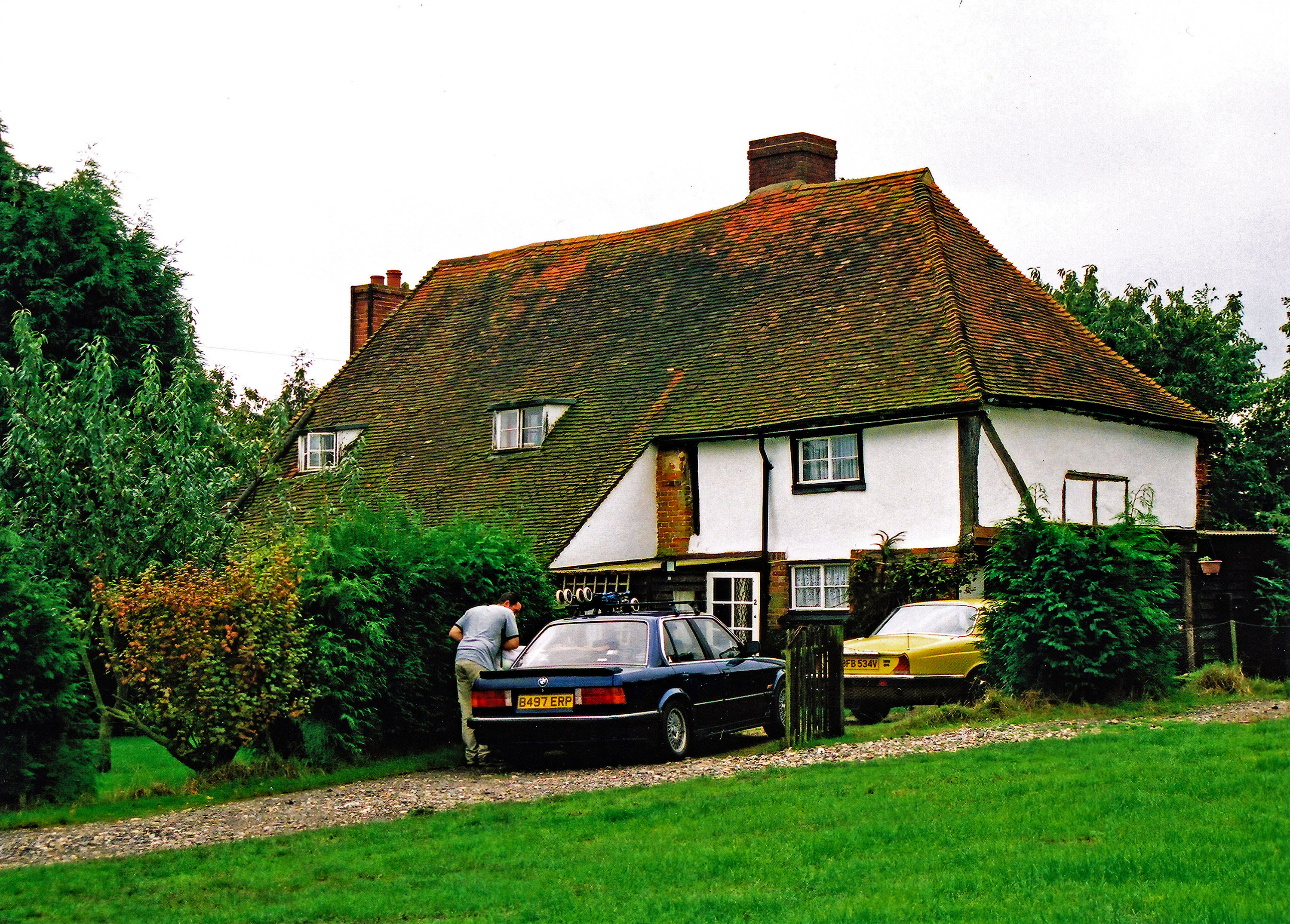
| LB/LYN/0046 | TQ 96 SE 1241 | The Old Vicarage, Lynsted Street - 16th C. | II | 2/81 L2-2-1083 |
| Vicarage Cottage, Lynsted Street - early 19th C. | Historic Interest | |||
| TQ 96 SW 216 | Iron Age Ditch and Pit on site of Stedlyn Farm (now St Pauls Court) | |||
| TQ 96 SW 217 | Possible Post Medieval Walled Garden, Lynsted, on site of Stedlyn Farm (now St Pauls Court) | |||
| LB/LYN/0047 | MKE85470 | Vicarage Farmhouse (formerly the Old School House), Lynsted Lane - 16th C. | II | 2/82 L2-2-989 |
| LB/LYN/0048 | TQ 96 SW 1089 | Wall Opposite St Peter & St Pauls Church, Lynsted Street - 16th C., 18th C. | II | 2/83 |
| LB/LYN/0049 | TQ 96 SW 1218 | Hillside House, Lynsted Street - 17th Century | II | 2/84 |
| LB/LYN/0050 | TQ 96 SW 1088 | Forge Cottage and the Old Forge adjacent, Lynsted Street - 18th C. | II | 2/85 |
| LB/LYN/0051 | TQ 96 SW 1239 | Forge House, Lynsted Street - 17th C. | II | 2/86 LS2-2-818 |
| Myrtle House, Lynsted Street - 18th C. | Local List | |||
| LB/LYN/0052 | TQ 96 SW 1240 | The Post Office, Lynsted Street - 16th C. | II | 2/87 |
| LB/LYN/0053 | TQ 96 SW 1087 | Church of St Peter & St Paul, Lynsted Street - 13th Century | I | 2/88 |
| LB/LYN/0054 | TQ 96 SW 1222 | Black Lion P.H., Lynsted Lane - 17th C. | II | 2/89 |
| MKE88926 | Farmstead to south west of Black Lion public house (completely demolished) | |||
| TQ 96 SW 1194 | King George VI - K6 Telephone Kiosk - c.1936 | II | 2/191 | |
| LB/LYN/0055 | TQ 96 SE 1103 and MKE85572, MKE88933, TQ 96 SE 111 |
Nouds Farmhouse (mentioned by Edward Hasted), Nouds Lane - 16th Century [and Regular courtyard multi-yard; and Farmstead north of Nouds Farm; Oasthouse SSW of Nouds Farm] | II | 3/90 |
| LB/LYN/0056 | TQ 96 SE 1143 and TQ 96 SE 61 |
Moss House, Nouds Lane (formerly 1-2 Moss Cottages) - 16th C., mid-19th C. [and post medieaval lime kiln nearby] | II | 3/91 |
| TQ 96 SE 203 | Lime kiln NNE of Moss House | |||
| LB/LYN/0057 | TQ 96 SE 1100 and MKE85567, MKE85571, MKE85568 |
Nouds House, Nouds Lane (formerly listed Nouds) - early 18th C. [and much altered loose courtyard; and Field Barn; and outfarm to West] | II | 3/92 |
| LB/LYN/0058 | TQ 96 SE 1142 | 1-2 Bishops Cottages (photograph of original building - 10Mb download), Nouds Lane - Badly damaged by fire 2004 and demolished. An authoritative archeological study for this building following its destruction, can be seen on the excellent website of the Canterbury Archeological Trust (PDF). | II | 3/93 |
| LB/LYN/0059 | TQ 96 SE 1099 | Tickham Cottage, Tickham Lane (formerly Farm Cottage, Lower Tickham) - 16th C. | II | 3/94 L2-2-515 |
| MKE85573 | Tickham Farm. Regular courtyard - remains. Only the farmhouse now remains | |||
| LB/LYN/0060 | TQ 96 SE 1066 and MKE85574 |
1-3 Lower Tickham Cottages, Tickham Lane - 15th C. [Loose courtyard with working agricultural buildings on three sides] | II | 3/95 |
| LB/LYN/0061 | TQ 96 SW 1111 | Lynsted Court, Toll Lane - 15th C., c.1600 | I | 2/96 L2-2-871 |
| MKE85472 | Lynsted Court (Sewards) Farmstead | |||
| LB/LYN/0062 | TQ 96 SW 1110 | Barn, Toll Lane (30 ydsWest of Lynsted Court) - 17th C. | II | 2/97 |
| KINGSDOWN | ||||
| Church Oast, Downcourt Road - mid-19th Century | II | 4/102 | ||
| TQ 9252 5863 | Church of St. Catherine - 1865 [By E.W. Pugin for Lord Kingsdown] | II | 4/103 | |
| MKE85419 | Farmstead adjacent to St Catherines Church | |||
| TQ 95 NW 46 and MKE85388 |
Great Higham Farmhouse, Downcourt Road - 16th C. [and loose courtyard, altered] | II | 4/104 | |
| TQ 95 NW 105 and TQ 95 NW 106 | Visigothic gold tremissis; and Merovingian gold tremissis (Under Motorway below bridge crossing to St Catherine's Church) | |||
| MKE85385 | Farmstead remains in Rushenden (Grove Cottage on Kingsdown Road) | |||
| TQ 9216 5790 | Barn (50 yds SE of Great Higham Farmhouse - 16th C. | II | 4/105 | |
| TQ 95 NW 66 | The Forge, Dungate Road - 18th C. | II | 4/106 | |
| TQ 95 NW 47 | The Malthouse, Hole Street - 18th C. | II | 4/107 | |
| MKE85421 | Kingsdown House, Hole Street - 18th C., mid-19th C. [A dispersed plan farmstead] | II | 4/108 | |
| TQ 95 NW 49 | Finch's (formerly Burley's Cottage), Hole Street - 16th C. | II | 4/109 | |
| TQ 95 NW 95 | Yew Tree Cottage, Hole Street - 16th C. | II | 4/110 | |
| TQ 95 NW 88 | Hole Street Farmhouse, Hole Street - 17th C. | II | 4/111 | |
| TQ 9271 5931 | West of Hole Street Farm. 4 gun battery, with generator building and guardroom but no command post. In excellent condition. |
|||
| TQ 95 NW 64 and MKE85420 |
Oast, Granary & Stores, 60 yds W of Hole Street Farmhouse - early-mid 19th C. | II | 4/112 | |
| GREENSTREET - NORTH SIDE | ||||
| TQ 96 SE 1118 | White Hall - 15th C. | II | 3/161 | |
| TQ 96 SE 1149 | Orchard Thatch - 17th C. | II | 3/160 | |
| Jubilee Memorial Pump - 1897 | Local | |||
| TQ 96 SE 1073 | No.57 (Alverley House) - 17th C. | II | 3/159 | |
| TQ 96 SE 1158 | No.117 early 19th C. | II | 3/158 | |
| Nos. 161 & 163 - 18th C. | Local | |||
| TQ 96 SW 1238 | Nos. 183 & 185 - 17th C. | II | 2/157 |